Blogs
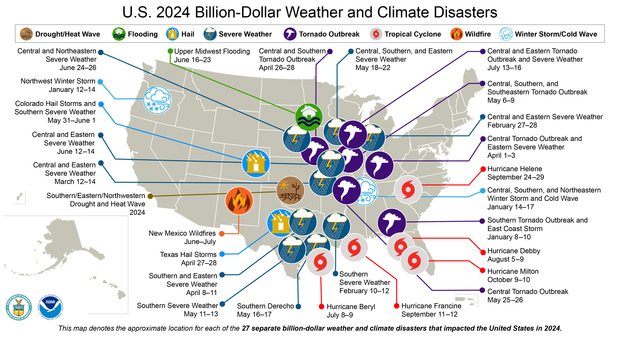
NOAA’s National Centers for Environmental Information (NCEI) has updated its 2024 Billion-dollar disaster analysis. In 2024, there were 27 individual weather and climate disasters with at least $1 billion in damages, trailing only the record-setting 28 events analyzed in 2023. These disasters caused at least 568 direct or indirect fatalities, which is the eighth-highest for these billion-dollar disasters over the last 45 years (1980-2024). The cost was approximately $182.7 billion.
This total places 2024 as the fourth-costliest on record, trailing 2017 ($395.9 billion), 2005 ($268.5 billion) and 2022 ($183.6 billion). Adding the 27 events of 2024 to the record that begins in 1980, th…
Read article
La Niña conditions emerged in the tropical Pacific in December. There’s a 59% chance La Niña will persist through February–April, followed by a 60% chance of neutral conditions in March–May. Read on for the recent observations that led us to declare the (long-awaited) onset of La Niña and lots of details for current and potential upcoming conditions.
Just the facts, ma’am
A quick briefing, if you’re just joining us—La Niña is one phase of the El Niño/Southern Oscillation (ENSO), a pattern of sea surface temperature and atmospheric changes in the tropical Pacific Ocean. La Niña’s signature is cooler-than-average surface water in the east-central Equatorial Pacific, while its counterpart…
Read article
Parts of the Midwest and East Coast have been blanketed by the first major snow of 2025, with temperatures dropping as fast as my New Year’s resolutions. Do we have the stratosphere, the polar vortex in particular [footnote #1], to blame (or thank) for this recent cold air outbreak? We don’t think so. This seems like a case of the polar vortex getting blamed for being a trouble maker, when it was actually minding its own business. We’ll tell you why below.
Our usual suspect has an alibi: the polar vortex has been strong
A common way in which the stratospheric polar vortex contributes to cold air outbreaks over the eastern U.S. usually involves two key ingredients.…
Read article
When we launched this blog last winter, the atmosphere came through for us with not one, but two breakdowns of the stratospheric polar vortex. That was very considerate of it, given that many winters pass without even a single one. With all the excitement that occurs when the stratospheric polar vortex is disrupted during a sudden stratospheric warming, our readers might wonder whether there is any way to predict weeks or even months ahead of time the likelihood that one (or more!) will occur this upcoming winter.
As we discussed last year, there are certain ingredients that need to come together to drive a sudden stratospheric warming. These can be boiled down to two main factors:
…
Read article
There’s a 59% chance that weak La Niña conditions will develop shortly. This is very similar to last month’s estimate, just applied to November–January. It’s true; if you read last month’s post, you can pretty much carry that information over to this month. However, we have lots of fun sciency details to talk about this month, so stick around!
The office holiday party
La Niña, the cool phase of the El Niño/Southern Oscillation (ENSO), is a coupled ocean-atmosphere pattern in the tropical Pacific Ocean. To qualify as La Niña conditions, we need to see (1) surface water in the tropical Pacific that is at least 0.5 °C (just shy of 1˚F) cooler than the long-term average (long-term=1991–202…
Read article